
The Shape of What Is Missing


Nicolas Flament and Santosh Dhungana on how mantle flow may have helped create and preserve the Great Unconformity
This interview has been edited for length and clarity.
The Conversation
The Gap
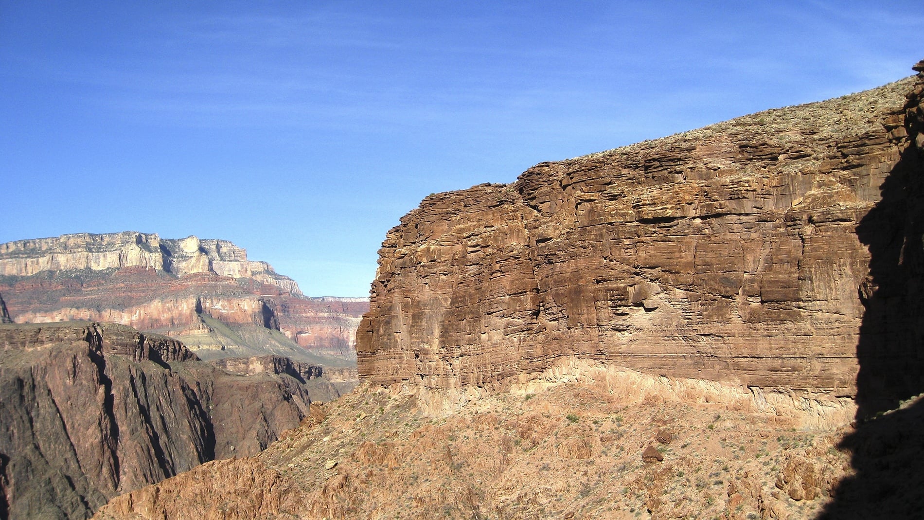
Nicolas Flament An unconformity is a type of contact between rock formations. It is often characterised by different angles in the rocks beneath and above. Unconformities are common. A few aspects make the Great Unconformity "great". It is spectacular where it was first identified in the Grand Canyon. The cliffs formed by the Colorado River reveal near-horizontal sedimentary rocks resting on older sedimentary rocks that have been tilted and faulted, or even turned into schist over time by temperature and pressure. The contact is sharp, and in places you can touch both rock formations with one hand. Geologists first identified the contact in the 1860s and, over time, dated the rock formations, revealing a gap spanning from 200 million years to over 1 billion years.
A second reason the Great Unconformity is significant is that the sedimentary rock formations above it contain fossils of animals with hard shells and skeletons for the first time. A third is that, in many places, the erosion surface beneath the sediment contains evidence of extensive glacial deposits. A fourth is its spatial extent; it has been identified in many places worldwide.
Nicolas Flament The Great Unconformity is a family of related unconformities, or gaps, that we have grouped under a single name. An analogy could be holes in a net or in a book. Imagine a book describing Earth's history. About three-quarters of the way through, some pages would have holes. The holes would vary in size and in how many pages they affect. The rock record is a bit like that. The Great Unconformity is not present everywhere, and where it is, the gap duration varies. Unconformities of a similar age occur in enough areas that geologists have proposed the concept of a great unconformity that links them all.
The Deep Earth
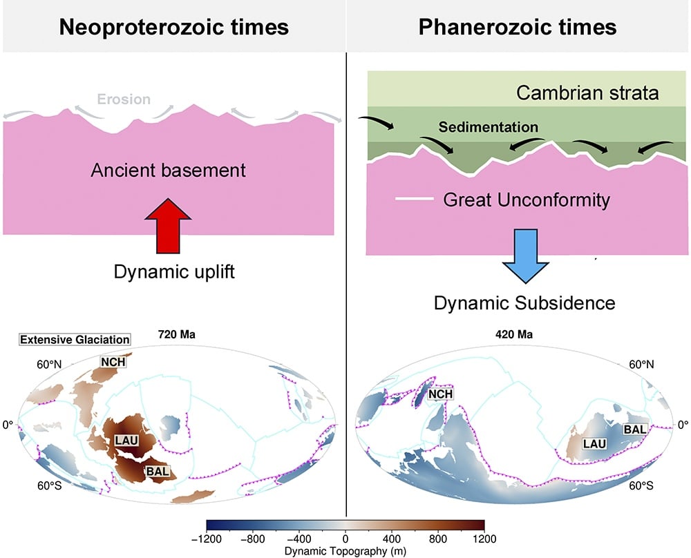
Nicolas Flament A familiar concept to start with is tectonic plates moving at Earth's surface. The motion of these tectonic plates is linked to motion deep within the Earth. Solid rock moves up and down in a layer extending between about 200 km and 2,900 km depth that geophysicists call the mantle. Downward motion occurs where rocks cooled at the surface are recycled into the Earth. Because mass is conserved, hot rocks come toward the surface to compensate for the downward motion of cold rock. The downward or upward motion of solid rock in the mantle pushes the surface down or up in a process called dynamic topography.
While we cannot measure the amplitude of these motions, evidence and models suggest it is about ten times smaller than the topography created by mountain belts where tectonic plates collide. So, with Mount Everest about 9 km high, the amplitude of dynamic topography is up to about one kilometre. Dynamic topography associated with deep mantle flow has a surface footprint of about 5,000 km: it can be recorded at the scale of a continent. Tectonic plates and the mantle within the Earth move at an order of magnitude of 1 cm to 10 cm per year (10 km to 100 km every million years). As a result, dynamic topography evolves slowly over millions of years. It can tilt and push entire continents up or down.
Nicolas Flament Evidence shows that the rocks beneath the sediments in the Great Unconformity were eroded at Earth's surface. So, the landscape was initially above sea level. The sediments that form the top layer of the Great Unconformity were deposited below sea level. So, the second step is needed, in which the same surface subsides below sea level. A third step is needed to preserve the contact. Renewed erosion could remove it from the record. Further sedimentation would bury it beneath younger rock layers. A single long rise followed by a single long sinking does not favour renewed erosion or sedimentation. That is why it does the job so well.
Nicolas Flament Our models start with a reconstruction of tectonic plate motions at Earth's surface over the past billion years. Geophysicists can establish the past latitude of continents from some rock samples. Further evidence comes from the nature and juxtaposition of rock formations, pointing to past mountain belts or rift zones. This tectonic reconstruction is uncertain. Continents only cover about one-third of the planet, and the oldest ocean floor is only about 200 million years old. The past longitude of continents cannot be ascertained.
We use the tectonic reconstruction as a surface boundary condition for a mantle flow model. We impose plate motions and the locations where cold lithosphere is recycled into the mantle. We compare model predictions with observations for the present and the past. One model prediction is dynamic topography, and one observation is the Great Unconformity.
Testing the Idea
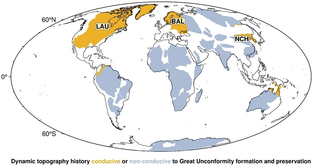
Nicolas Flament There were a couple of surprises when we analysed the results. We had not anticipated a single rise followed by a single fall for any continent over one billion years. The second surprise was that this pattern was consistent for three regions where the Great Unconformity is best documented. We varied model parameters to verify the sensitivity to different inputs. The result was consistent across all models. Further work at continental scale is needed to verify whether the Great Unconformity could occur on other continents. This effort is underway as data from several continents are compiled in the database Macrostrat by Professor Shanan Peters and his team at the University of Wisconsin–Madison.
Unconformities of a similar age in Australia, Africa, and elsewhere are less widespread, so they are less likely to be linked to deep mantle flow. Smaller-scale solid-Earth processes could have caused these unconformities. For Australia and South America, our model predicts two cycles of continental up and down, as opposed to one cycle for Laurentia, Baltica and North China. The two-cycle scenario, consistent with the first-order sediment record preserved on each continent, is less favourable for preserving the Great Unconformity, as it could be eroded or buried under younger rocks.
Nicolas Flament Because of its scale and amplitude, dynamic topography does not create relief with significant slopes. River erosion is most efficient on slopes. Geological evidence suggests extensive glaciations between about 720 million years ago and 635 million years ago. Ice sheets are about 10 times more effective at scouring continental surfaces than rivers, including at lower elevations. Interestingly, our models predict a main uplift phase during that time, between 800 and 600 million years ago for Laurentia, Baltica and North China.
We propose that mantle-driven uplift and glacial erosion worked together to form the Great Unconformity: erosion by ice sheets would eventually level the surface and stop without uplift. The breakup of a supercontinent would be most visible along its margins. However, the Great Unconformity extends deep into modern North America, which is more consistent with a deep Earth driving force.
What Is Missing
Nicolas Flament An unconformity reflects a gap in the geological record at a given place. In this sense, unconformities point to missing rock. To observe an unconformity, it must be preserved as a contact between two rock formations of different ages. A preserved unconformity shows that the landscape changed and sedimentation stopped for a period. Geologists piece the puzzle together by looking for information elsewhere. That information helps them fill the gaps, or, to come back to the analogy of the book, fill the holes in the pages.
In the case of the Great Unconformity, the record is indeed what remains. It tells us of extensive erosion followed by extensive sedimentation, preserved on continents that we can observe today. Where the erosional surface is visible, there is sometimes evidence of past ice-sheet motion in the rocks. What is unusual about the Great Unconformity is the long period without sedimentation and its extent.
Continued erosion would point to one erosional event only. Continued sedimentation would result in an accumulation of strata in low-lying areas, with the youngest strata at the top. Each scenario is finite in time, as erosion or sedimentation eventually flattens the topography.
Nicolas Flament The long erosion would have transported minerals to the seas. Some of these minerals contain elements that are essential to life, such as phosphorus and calcium. Geologists think the Cambrian oceans were rich in calcium following a phase of extensive erosion. This abundance of calcium in the oceans coincides with the time when life forms first used calcium to build skeletons and shells. Shallow continental seas are rich in nutrients and sunlight, which favours life. It is therefore likely that the long erosion and return of the seas helped set the stage for the Cambrian explosion.
Nicolas Flament When looking at landscapes, I often wonder whether tectonic motions shaped them or whether they require a different explanation. One prominent example is southern Africa, which is more elevated than expected without mountains formed by continental collision. The southern African landscape is thought to reflect a deep mantle push. Similarly, the spectacular Bunda Cliffs (also called the Nullarbor Cliffs) of southern Australia express continental uplift as Australia moved away from a mantle downwelling.
The Researchers
Santosh Dhungana My PhD project aims to understand how the co-evolution of deep Earth processes and surface forces shaped the landscape and probably created the environment conducive to the explosion of complex life. The Great Unconformity, a vast gap in geological records spanning hundreds of millions of years, lies at the centre of this story. Yet its origin remains one of geology's enduring mysteries. We set out to test whether vertical movements (dynamic topography) generated by slow mantle creep, hundreds of kilometres deep and spanning thousands of kilometres over millions of years, sculpted the continents and formed and preserved the Great Unconformity.
My journey into deep Earth research began when I joined this PhD position. Before that, I worked at the intersection of climate, water, and sanitation in contemporary contexts. The challenge was not only learning the language of the field and the scientific tools used, but also finding the right scale at which to ask the question. Luckily, I did not have to start from scratch. Nicolas had already run the mantle flow models, and I leveraged my large-scale spatio-temporal data analysis skills to analyse model outputs.
We began by testing model predictions at individual locations and soon realised that the Great Unconformity is vast and well documented at the continental scale (North America), and the predicted surface motions driven by the mantle also operate at the continental scale. We grouped geological regions that shared similar patterns of dynamic topography and found that a prolonged cycle of uplift followed by subsidence was most conducive to forming and preserving the Great Unconformity.
Nicolas Flament Santosh and I are now working with Tristan Salles from The University of Sydney to study the effect of mantle convection on landscape evolution from 540 million years ago. We will again compare the model predictions to the geologic record of sedimentation.
Another aspect of my research is linking models of mantle convection and core convection with observations of past geomagnetic field behaviour. We want to understand why the geomagnetic field apparently stopped reversing between 120 and 83 million years ago (it usually reverses every million years or so). We also want to understand why the magnetic field was low-intensity and often reversed between 635 and 540 million years ago.
Conclusion
We tend to read the past through what survives: a fossil, a layer of ash, a line of sandstone. The Great Unconformity asks us to read something else, the shape of what is gone. In the Grand Canyon, a hand can rest on rock half a billion years old and, in the same gesture, touch rock that is hundreds of millions of years older, in places more than a billion. The time between them has left no layer of its own.
What this study suggests is that even an absence has a history. To be seen today, the gap had to be made and then kept. Rock had to be lifted and worn away, the worn surface had to sink beneath returning seas, and then it had to be left alone for hundreds of millions of years. The models of Nicolas Flament and Santosh Dhungana place the cause of that sequence far below the surface, in the slow movement of the mantle. Ice may have done much of the cutting, but the deep Earth may have decided where the cutting happened and what survived of it.
There is something quietly humbling in that idea. The surface we walk on, and the record we read from it, may be shaped from beneath by forces we cannot see and can only reconstruct. The missing pages of the Great Unconformity may also mark a turning point for life, when animals with hard shells and skeletons first appeared in shallow seas enriched by what the long erosion had carried down. A gap in the rock, in this view, is not only a loss. It may also be part of how the world of animals took shape.
Explore More
The Study
The paper behind this conversation, published open access, with the full set of models and maps.
The Research Santosh Dhungana and Nicolas Flament, The deep Earth origin of the Great Unconformity , Nature 659, 106–112 (2026).
Scraped by Ice
Seven years earlier, a team led by Brenhin Keller argued that glaciers did the removing. Chemical traces in zircon crystals from around the world point to an enormous pulse of erosion late in the Neoproterozoic, which the authors attribute to the ice sheets of Snowball Earth wearing away an average of three to five vertical kilometres of rock. The Wollongong study does not set this aside. It proposes that uplift from below kept the ice at work, and it highlights which continents this could have occurred on.
Earlier Research C. Brenhin Keller et al., Neoproterozoic glacial origin of the Great Unconformity , Proceedings of the National Academy of Sciences 116 (4), 2019.
A Gap and the First Shells
Shanan Peters and Robert Gaines studied rock data from hundreds of sites across North America and proposed that the making of the Great Unconformity changed the chemistry of the oceans. Long weathering of exposed continental rock, followed by the spread of shallow seas, would have delivered the ingredients that animals began using to build shells and skeletons. In their account the gap is not only a loss of record but a possible trigger for the Cambrian explosion.
Earlier Research Shanan E. Peters and Robert R. Gaines, Formation of the 'Great Unconformity' as a trigger for the Cambrian explosion , Nature 484, 2012.
About the Researchers
Nicolas Flament is an Associate Professor at the University of Wollongong, Australia. He studies how the solid Earth deforms over tens of millions of years by combining geodynamic models with geological and geophysical observations. He completed his PhD jointly at the École Normale Supérieure de Lyon and the University of Sydney and has been awarded a 2016 Australian Research Council (ARC) Discovery Early Career Award Fellowship, the 2017 Outstanding Early Career Scientist Award of the European Geosciences Union's Geodynamics Division, the 2021 Anton Hales Medal of the Australian Academy of Science, the 2021 David Syme Research Prize, and a 2023 ARC Future Fellowship.
Santosh Dhungana is a PhD candidate at the University of Wollongong and lead author of the Nature study on the Great Unconformity. Before turning to the deep Earth, he worked at the intersection of climate, water, and sanitation, taking an integrated, interdisciplinary, and participatory approach that brought together numerical modelling, remote sensing, field observations, and stakeholder insights. His doctoral research examines how deep Earth processes and surface forces together shaped ancient landscapes and the environment in which complex life diversified.