The Mystery of the 'Wheel of Ghosts': Ancient Observatory or Something Else?
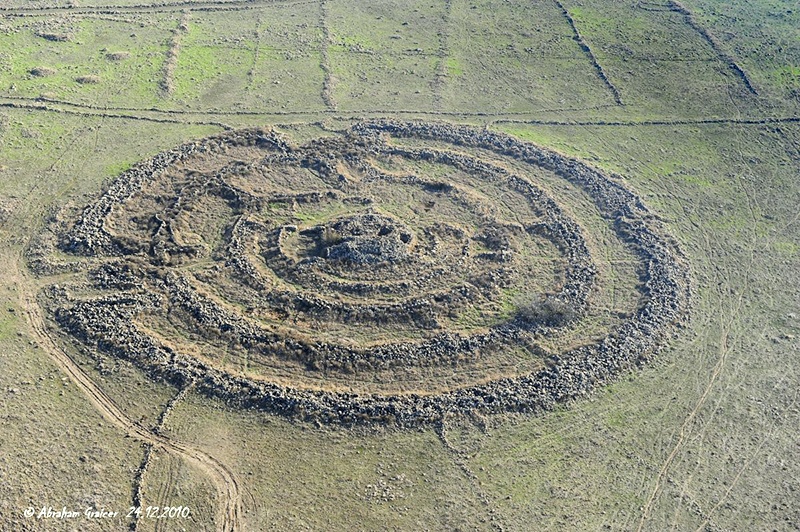
High atop the windswept plateaus of the Golan Heights, an ancient megalithic structure has long captured the imagination of archaeologists and mystics alike. Its massive stones, arranged in perfect concentric circles, earned it the haunting name “Wheel of Ghosts” – Rujm el-Hiri in Arabic. For generations, this prehistoric monument has guarded its secrets, sparking endless debates about its creators and purpose.
Now, an innovative research collaboration between geophysicists from the Tel Aviv University and archaeologist from the Ben-Gurion University of the Negev has peeled back layers of mystery surrounding this enigmatic site. Their findings, published in Remote Sensing, not only challenge long-held beliefs about the structure’s purpose but reveal an unexpected truth that has been literally shifting beneath our feet for millennia.
Lead researcher Prof. Lev Eppelbaum of Tel Aviv University’s Department of Geophysics shared insights about this interdisciplinary investigation and its unprecedented findings.
Archaeological Treasure Trove
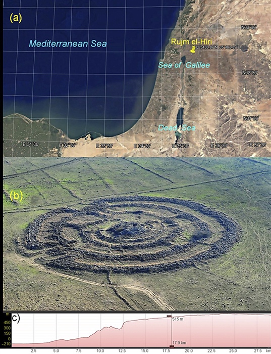
Israel’s archaeological landscape offers an inexhaustible chronicle of human history. With an astonishing 30,000 documented sites and potentially just as many waiting to be discovered beneath modern structures, Israel boasts what might be the world’s highest concentration of archaeological treasures per square mile. In this rich tapestry of human history, the area east of the Sea of Galilee emerges as a particularly fascinating region, where Rujm el-Hiri, a monumental stone circle dating back to the Late Neolithic period, stands as a silent sentinel to prehistoric human achievement.
An Unexpected Research Gap
Yet despite the region’s archaeological wealth, remote sensing studies in northern Israel have been surprisingly limited. “It was almost unbelievable,” notes Prof. Lev Eppelbaum, who has authored nearly 460 publications, including 92 focused on Archaeological Prospection. His comprehensive literature review revealed only a single published study exploring remote sensing applications for archaeology in northern Israel. This discovery sparked the formation of an interdisciplinary team of geophysicists and archaeologists, whose collaboration would prove crucial in unlocking Rujm el-Hiri’s secrets.
Revolutionary Technology and Integrated Methods
In an effort to gain unprecedented insight into the monument, the researchers analyzed more than 600 satellite images captured under a range of conditions and from diverse angles. These images were then subjected to advanced filtering processes to reveal features invisible to standard observation. On the ground, the team employed high-precision magnetic surveys, ground-penetrating radar (GPR), and electrical resistivity tomography (ERT). The combination of these techniques, interpreted through methods based on information theory, allowed the researchers to construct a robust three-dimensional visualization of subsurface features at and around the site. This integration of remote sensing and geophysical data provided novel perspectives on not only the concentric rings of Rujm el-Hiri but also on various hidden archaeological elements in the broader vicinity.
The Earth Moves: A Startling Discovery
One of the most striking findings was the gradual counterclockwise rotation of the entire structure over the last 4,000 to 4,500 years. This rotation, amounting to a lateral displacement of approximately 30 to 35 meters from its original position, became apparent after a meticulous examination of multiple data sets. These data sets included GPS measurements, paleomagnetic records, and satellite-derived gravity surveys. The research indicates that Rujm el-Hiri sits atop a dynamic geologic environment exerting continuous stress on the monument’s foundations. This revelation prompts scholars to reconsider the possibility that the monument’s builders intended it to align precisely with celestial bodies, given that such an orientation would have been compromised by ongoing tectonic movement.
Geomagnetic Analysis and Tectonic Reconstruction
A deeper understanding of how Rujm el-Hiri has shifted emerges from studies of tectonics, geomagnetics, and structural models. Scientists have identified a large-scale counterclockwise geodynamic structure beneath the Eastern Mediterranean, supported by fifteen independent lines of evidence. These lines of evidence include paleomagnetic analyses, satellite-derived and surface (sea) gravity data, geoid anomaly isolines, and paleobiogeographical information, among other tectonic-structural studies. The cumulative effect is a gradual counterclockwise motion of underlying slabs, measured at approximately eight to fifteen millimeters per year. As Rujm el-Hiri lies within the domain of this rotation, it too has shifted along with the ground beneath it, challenging interpretations that rely on long-term positional stability.
A Landscape of Undiscovered Wonders
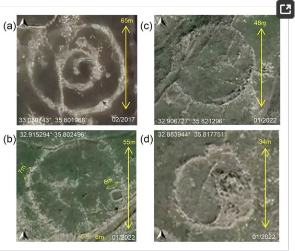
Beneath the enigmatic stone circles of Rujm el-Hiri, advanced imaging and geophysical techniques have uncovered a hidden landscape. A sprawling network of ancient channels, potentially designed for both irrigation and defense, crisscrosses the terrain like the arteries of a long-lost civilization. Scattered among them are small reservoirs, each capable of holding two to four meters of water—essential lifelines in an unforgiving climate. These findings suggest that the prehistoric inhabitants employed sophisticated resource management strategies, revealing a vibrant community that extended far beyond the iconic site. As Dr. Olga Khabarova explains, “Each discovery adds another piece to the puzzle, helping us understand not just how this site was used, but how an entire civilization lived and thrived here.” Far from an isolated monument, Rujm el-Hiri now emerges as a cornerstone in a larger system of ancient engineering, painting a vivid picture of ingenuity and resilience.
Implications Beyond Borders
The lessons learned in the Golan Heights have the potential to resonate far beyond the confines of Israel. Professor Eppelbaum believes that the same multidimensional research strategies used to analyze Rujm el-Hiri could be applied to other ancient monuments, such as the pyramids of Giza or various megalithic sites around the world. If these celebrated landmarks were also subject to similar tectonic influences, interpretations of their construction, alignment, and use may need to be re-evaluated. Such a possibility underscores the importance of geology and geomagnetics in global heritage studies, bridging fields that traditionally operate in relative isolation.
The Future of Ancient History
The archaeological team’s follow-up research plan will integrate three advanced exploration methods:
– Remote sensing analysis: Utilizing remote sensing data such as satellite imagery to identify new features of the site from a macroscopic perspective.
– Surface geophysical survey: Employing geophysical methods such as ground-penetrating radar and high-precision magnetic surveys to conduct detailed exploration of the site and obtain subsurface structural information.
– Archaeological excavation: Based on the results of remote sensing analysis and geophysical surveys, targeted archaeological excavations will be carried out in hopes of discovering more physical evidence.
This comprehensive research strategy is expected to reveal more of the unsolved mysteries surrounding the “Wheel of Ghosts” and provide important evidence for a deeper understanding of the historical and cultural significance of this enigmatic site.
Rethinking an Ancient Site
Discussions with project participants, including Prof. Lev Eppelbaum, illustrate how these new findings are reshaping perceptions of Rujm el-Hiri. The conspicuous absence of typical domestic artifacts, such as ceramics, suggests that the site may not have accommodated day-to-day habitation. Instead, the elaborate concentric rings and attendant infrastructure point to a carefully planned, multi-purpose complex, whose original usage is likely to have been both practical and culturally significant. With evidence now pointing to slow tectonic rotation, it is possible that the site’s initial design or alignment was compromised over time by forces beyond its builders’ control.
Conclusion: The Past Meets the Future
The slow rotation of the “Wheel of Ghosts” reveals that ancient structures are not static relics but witnesses to geological change. This discovery not only disproves its theorized role as a prehistoric observatory but also demonstrates how ancient humans adapted to complex geographical environments. Modern remote sensing and geophysical technologies have provided new perspectives, and as research continues, this mysterious structure may reveal more secrets about the interplay between human ingenuity and Earth’s forces.
Select References
Eppelbaum, L.V. (2010). Archaeological geophysics in Israel: Past, Present, and Future. Advances in Geosciences, 24, 45-68.
Eppelbaum, L.V., et al. (2021). Giant quasi-ring mantle structure in the African-Arabian junction: Results derived from the geological-geophysical data integration. Geotectonics, 55(1), 67-93.
Eppelbaum, L.V., Katz, Y.I., & Ben-Avraham, Z. (2024). The reasons for enormous accumulation of the geodynamic tension in Eastern Turkey: a multidisciplinary study. Geology Geophysics and Earth Science, 2(2), 1-28.